
A memorable US national parks road trip needs a route you can enjoy, not a map with the most pins. This 12-day journey connects Utah’s five national parks—Zion, Bryce Canyon, Capitol Reef, Arches and Canyonlands—between Las Vegas and Salt Lake City. It pairs major landscapes with short and moderate walks, uses real paved road connections and leaves a flexible day near Moab.
This is our recommended Southwest route for travelers who want a varied first national parks driving vacation. It is not a claim that one route is best for every season or traveler. The plan favors a standard passenger car, comfortable gateway stays and time outside the vehicle. Technical canyon trips, remote four-wheel-drive roads and long summit hikes are optional trips requiring separate preparation.
Reviewed September 26, 2026. The route has been checked against current NPS access information. Closures and weather can still change after review. Allow 12 days for the road trip; if your flight leaves Salt Lake City early, add an overnight there and fly on day 13, or move the final drive to day 11 and give up the Moab buffer.
If you have one week and want the Grand Canyon included, use our 7-day Las Vegas, Grand Canyon and Zion itinerary. That separate loop returns to Las Vegas and uses two park bases rather than compressing all five Utah parks into seven days.
Route overview: five parks in 12 days
On a small screen, swipe the table sideways to see every column.
| Trip element | Recommended plan |
|---|---|
| Start / finish | Fly into Las Vegas (LAS); finish in Salt Lake City (SLC) |
| Parks | Zion → Bryce Canyon → Capitol Reef → Arches → Canyonlands, Island in the Sky district |
| Main roads | I-15; UT-9; US-89; UT-12; UT-24; I-70 / US-191; US-6 / I-15 |
| Distance | About 1,000–1,100 miles with local sightseeing; core mapped route is about 833 miles |
| Driving | Core route about 18.4 hours; allow roughly 23–26 hours with park drives, before sightseeing stops or queues |
| Preferred season | Late September–early October; May is an alternative with high-elevation weather checks |
| Pace | 11 nights before the day-12 drive, plus an optional final Salt Lake City night |
| Vehicle | Standard passenger car for the suggested paved route; check current Zion size restrictions if renting anything larger |
National parks road trip map
Swipe the map sideways on mobile, or open the full-size map. The numbered list below provides a readable text alternative.
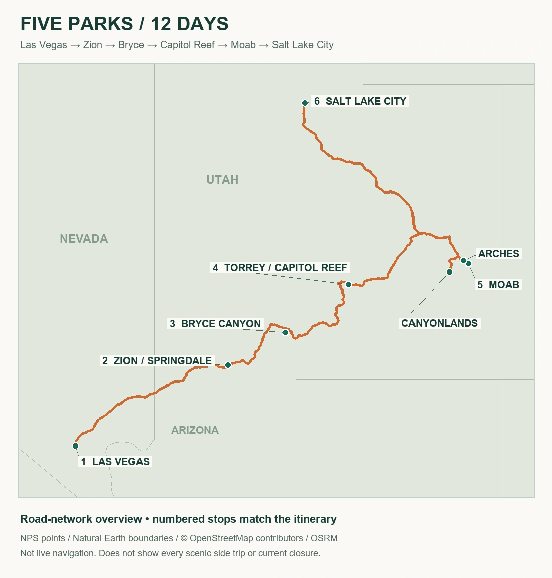
Map order: 1. Las Vegas; 2. Springdale/Zion; 3. Bryce Canyon; 4. Torrey/Capitol Reef via Escalante and UT-12; 5. Moab for Arches and Canyonlands; 6. Salt Lake City. Arches and Canyonlands are separate out-and-back drives from Moab, not a road crossing through either park.
What the mileage and drive times include
The mapped road network totals approximately 833 miles and 18.4 hours between the stated gateways and visitor-center stops. It includes the Zion east-side road connection, the UT-12 route through Escalante, the Moab–Arches visitor-center excursion and the Moab–Island in the Sky visitor-center excursion. It does not include every viewpoint road inside each park, driving to individual hotels or searching for parking.
The headline estimate adds a planning allowance of roughly 200 miles and five to eight hours for park drives and local movement. That allowance is an estimate, not an independently measured fixed itinerary. Your hotel locations and chosen viewpoints determine the final total. Road-network times also exclude meals, shuttle rides, entrance queues, roadwork and time spent enjoying the scenery. Use live navigation and current closures on the day; never use this orientation map as the sole navigation source.
The 12-day itinerary at a glance
On a small screen, swipe the table sideways to see every column.
| Day | Base that night | Main plan | Driving to allow |
|---|---|---|---|
| 1 | Las Vegas | Arrive, collect vehicle, buy supplies | Local only |
| 2 | Springdale | Las Vegas → Zion gateway; easy orientation | About 164 miles / 3–3.5 hours, plus stops |
| 3 | Springdale | Zion Canyon with shuttle and a short walk | Local roads and shuttle time |
| 4 | Bryce Canyon City or nearby | Zion east side → Bryce Canyon | About 86 miles / 2–2.5 hours, plus stops |
| 5 | Bryce Canyon City or nearby | Amphitheater viewpoints and suitable walk | Local park driving |
| 6 | Torrey | UT-12 through Escalante and Boulder | About 115 miles / 3 hours at the wheel; allow 5–6 hours overall |
| 7 | Torrey | Capitol Reef and Fruita | About 22 miles return to visitor center, plus open park roads |
| 8 | Moab | UT-24 → I-70 / US-191; settle in | About 156 miles / 3–3.5 hours, plus stops |
| 9 | Moab | Arches; Windows area and selected viewpoints | Local drive plus the in-park scenic road |
| 10 | Moab | Canyonlands, Island in the Sky | About 65 miles return to visitor center, plus viewpoints |
| 11 | Moab | Weather buffer, second short outing or rest | Optional local driving |
| 12 | Salt Lake City if needed | Moab → Salt Lake City | About 234 miles / 4.5–5 hours, plus breaks |
The day-by-day route
Day 1: Arrive in Las Vegas and make the next morning easy
Use the arrival day for the unglamorous tasks that protect the rest of the trip: collect the car, inspect it, understand the fuel policy and confirm whether a one-way drop in Salt Lake City is allowed at the quoted price. Check the spare-tire or roadside-assistance arrangement. Buy groceries, refillable water containers and picnic food before heading into smaller gateway towns.
Stay in Las Vegas if you have flown a long distance or landed late. Driving directly to Zion after a tiring flight trades a useful night’s sleep for little real sightseeing time. Load offline maps for the entire route and save accommodation addresses and park confirmations. Springdale uses Utah time; check local time rather than assuming your departure and arrival clocks match.
Day 2: Las Vegas to Springdale, with room to settle in
Follow I-15 toward southwestern Utah, then approach Springdale on UT-9. The core drive is about 164 miles, roughly three to three and a half hours before stops. Have lunch, check in and find the visitor-center approach and any local shuttle stop you will use tomorrow. A modest first afternoon helps everyone adjust to the dry climate and the pace of the trip.
If time and current conditions allow, take a short easy outing near the visitor center rather than starting a major canyon hike. Springdale is the most convenient town for this plan; Hurricane or La Verkin can cost less but add driving. Choose based on the actual room price, parking arrangements and time you will spend commuting, not just distance on a booking map.
Day 3: Spend a full day in Zion Canyon
When the Zion Canyon shuttle operates, use the park’s shuttle system for the main canyon rather than expecting to drive to every trailhead. Build the day around the canyon scenery, visitor interpretation and Riverside Walk, approximately 2.2 miles round trip with about 57 feet of elevation gain. It is a comparatively gentle choice in ordinary dry conditions, but check current access and watch your footing.
Riverside Walk ends where a very different outing begins. The Narrows involves walking in the river and requires attention to flow, flash-flood risk, conditions and suitable preparation. It is not an automatic continuation of an easy path. Angels Landing likewise requires its own permit and is not included in this default itinerary. Spend the afternoon at a comfortable pace and remain in Springdale for a second night.
Day 4: Cross Zion’s east side and continue to Bryce Canyon
Drive UT-9 east through the Zion–Mount Carmel corridor, then connect with US-89 and UT-12 toward Bryce Canyon. The mapped visitor-center connection is about 86 miles, usually a little over two hours of driving before delays or scenic stops. Sandstone slopes and the changing elevation make the transfer itself part of the trip. Stop only at legal pullouts and leave time for tunnel traffic.
Current vehicle-size restrictions are crucial if your rental is an RV, large van or trailer combination. New limits took effect June 7, 2026; consult the official dimensions before booking a vehicle for this road. Do not assume a tunnel escort or an older blog’s permit advice solves the issue. At Bryce, make a short first look from an open rim viewpoint, then rest as you adjust to the substantially higher elevation.
Day 5: Give Bryce Canyon a full day
Start with the amphitheater rather than immediately driving every mile of the park road. The rim section between Sunrise and Sunset Points is about one mile round trip with roughly 40 feet of elevation gain. It offers extensive views without committing to a steep descent. Even a short walk can feel different at Bryce’s elevation, so pace the first outing and bring layers.
If your group wants a route below the rim, choose it after checking the current trail report, weather and total ascent on the return. Snow, mud and seasonal closures change the options. You do not need a below-rim hike to justify a full day: combine several open viewpoints, visitor interpretation and a second look as the light changes. Stay a second night near Bryce so the scenic UT-12 transfer does not compete with the park.
Day 6: Follow UT-12 to Torrey via Escalante and Boulder
This is a scenic transfer day, not a race between parks. Follow UT-12 through the Escalante and Boulder area toward Torrey. The route is approximately 115 miles and roughly three hours at the wheel, but allow five or six hours for food, photographs and short safe stops. Curves, changing elevation and exposed sections reward a relaxed pace and a driver who can focus fully on the road.
Fuel before you need it, carry water and do not add a remote dirt-road shortcut because it appears shorter on a map. A passenger-car itinerary does not include the region’s backcountry roads. If a storm or early snow affects the higher road, check conditions and revise the transfer. Arrive in Torrey with enough time to settle in; tomorrow is reserved for Capitol Reef rather than squeezed into the last hour of daylight.
Day 7: Explore Capitol Reef from Torrey
Start around Fruita and the visitor center, then use open roads and short walks to understand the Waterpocket Fold landscape. The petroglyph boardwalk offers a useful brief stop. Hickman Bridge is a more substantial option: approximately 1.8 miles round trip and 400 feet of elevation gain, with uneven terrain and sun exposure. Choose it in appropriate conditions, carrying water and turning back before heat or weather becomes a problem.
At the September 26 review, Capitol Gorge was closed and recent storms had affected roads. Do not make the gorge a guaranteed activity. Check Scenic Drive conditions before heading out and follow current restrictions. Fruita orchard access and fruit availability are seasonal, not a promised included experience. A second Torrey night gives you space for a viewpoint, a walk and a quiet evening without pushing on to Moab tired.
Day 8: Drive from Torrey to Moab
Continue east on UT-24 and connect via I-70 and US-191 to Moab. Allow about 156 miles and three to three and a half hours before breaks, depending on the precise start and hotel. The route traverses open country where services are less frequent than city travelers may expect. Check fuel early and carry enough food and water that a closed restaurant does not dictate the day.
Use the afternoon to check current Arches and Canyonlands alerts, choose your next morning’s route and get supplies for several park days. Moab is the practical common base, but the parks are not interchangeable entrances to the same landscape. Arches is just north of town; Island in the Sky needs a longer drive. Keeping four nights here avoids repeated packing and creates a real weather or rest buffer.
Day 9: Explore Arches with a manageable walking plan
Arches did not require a timed-entry reservation in 2026, but busy periods can still bring delays or temporary capacity controls. Start early enough to avoid building the day around a congested entrance. Visit the Windows area and consider Double Arch, about 0.6 miles round trip with roughly 30 feet of elevation gain on a short but uneven path. Add selected roadside viewpoints rather than assuming you must hike to every famous formation.
If Delicate Arch is a priority, research its longer exposed route and match it to your ability and the day’s heat. Do not substitute the short Double Arch statistics for a different hike. Stay on durable surfaces and marked trails, protect biological soil crust and carry water even when the parking lot seems close. Return to Moab for a relaxed evening; tomorrow’s mesa country deserves another fresh start.
Day 10: Visit Canyonlands’ Island in the Sky district
Drive to Island in the Sky, allowing about 65 miles round trip between Moab and the visitor center before additional park roads. The district is a high mesa with expansive overlooks, not a through-route down into the canyon. Choose open viewpoints such as Green River Overlook and consider Mesa Arch, approximately 0.6 miles with about 56 feet of elevation change. Uneven ground and unguarded cliff edges demand attention despite the short distance.
Current construction can affect Grand View Point, so treat it as an option only if access is confirmed. The Needles is a separate district with a different approach and is not a quick extension of this day. White Rim and other backcountry roads require separate permits, suitable vehicles and preparation; they are outside this paved-road plan. Return to the same Moab base rather than adding an unnecessary late transfer.
Day 11: Use the buffer intentionally
A flexible day makes the whole itinerary more realistic. Use it to recover an outing lost to weather, revisit an accessible Arches area in different light or simply sleep later and have an unhurried meal. A road trip with several early starts and changing elevations can be tiring even when the walks are short. Rest is a valid use of a vacation day, not a planning failure.
Avoid filling this day in advance with another distant park. If your return flight from Salt Lake City is early on day 12, move the long final drive here and stay near the airport. That version has less flexibility but protects the flight. If you keep the Moab night, organize bags and the vehicle this evening so tomorrow’s departure is straightforward.
Day 12: Finish in Salt Lake City without gambling on the flight
The Moab-to-Salt Lake City transfer is about 234 miles, commonly four and a half to five hours at the wheel before breaks or traffic. Plan extra time for refueling, rental return, airport procedures and any construction or weather delay. A route estimate ending in the city is not a guarantee of arrival at your airline’s gate.
The most relaxed finish is a Salt Lake City overnight and a flight the next day. If flying today, choose a sufficiently late departure and leave a substantial buffer; reassess against live conditions. Do not add a major sightseeing detour simply because the route appears shorter than earlier scenic days. Finish with the time margin you would want if the final hour becomes the slowest hour of the trip.
Best time for this road trip
Late September to early October offers a useful balance for this particular route: lower deserts are generally more comfortable for walking than midsummer, while high-elevation roads may still be practical. It is not uniformly warm. Bryce can have freezing mornings, and an early storm can affect UT-12 or park roads. Pack for a meaningful range of temperatures and check forecasts separately for Springdale, Bryce, Torrey and Moab.
May is a reasonable alternative, with the same need to monitor snow and cold at higher elevations. Summer adds heat exposure, making early starts and shorter desert walks more important; a family seeking relaxed midday hiking may prefer a different season. Winter can be beautiful but changes this into a weather-dependent itinerary with snow, ice and fewer services. Use the fall parks guide or winter parks guide to compare those tradeoffs.
Where to stay and what to reserve first
This plan uses one night in Las Vegas, two near Zion, two near Bryce, two in Torrey and four in Moab, followed by an optional Salt Lake City night. Springdale minimizes Zion commuting; Bryce Canyon City and nearby communities provide access to Bryce; Torrey is the practical Capitol Reef base. In Moab, compare parking, kitchen facilities and location rather than changing hotels to save a small nightly amount.
Book flights and the one-way rental as a coordinated package of decisions. A low flight price can be outweighed by a rental drop charge. Next, secure the gateway nights with cancellation terms you understand, then book any defining activity. Camping requires its own reservations and equipment; an entrance pass does not reserve a site. Do not assume dispersed camping is permitted at any roadside pullout. Use official land-manager rules for the exact location.
Entrance fees, passes and reservations in 2026
Check your party’s eligibility before comparing pass prices. In 2026, the America the Beautiful annual pass costs $80 for U.S. citizens and residents and $250 for non-U.S. residents. At 11 specified parks or park groups, non-U.S. residents age 16 and older generally pay an additional $100 per person unless covered by a qualifying pass. Several parks in these guides are on that list. See the official pass options and nonresident fee and pass-coverage rules before buying.
A valid America the Beautiful pass or qualifying park annual pass covers the applicable entrance and nonresident fees for the group defined by its terms. Coverage depends on whether admission is charged per vehicle or per person; do not assume one pass covers an unlimited group. Camping, tours, transportation and reservation charges can remain additional costs.
An entrance pass is not a timed-entry reservation, a campsite booking or a hiking permit. For example, Angels Landing in Zion requires its own permit. Great Smoky Mountains parking tags are separate from entrance passes. Keep confirmation numbers available offline and match the reservation to the entrance, vehicle and date you will actually use.
Current access checks for the five parks
- Zion conditions / fees and Zion–Mount Carmel large-vehicle restrictions: check the actual dimensions of your vehicle and the current shuttle season.
- Bryce Canyon conditions / fees: confirm open roads and below-rim trails; weather and elevation matter.
- Capitol Reef conditions / fees: check Scenic Drive, recent flooding and gorge closures before choosing a walk.
- Arches conditions / fees: confirm entry policy for your travel year and any trail closures.
- Canyonlands conditions / fees: select Island in the Sky and verify construction impacts; do not confuse it with the Needles.
Build a practical park-trip budget
Price this route using your actual dates, party size and accommodation preferences. Include the one-way rental drop charge and every gateway night, then compare the full trip total rather than headline room rates.
On a small screen, swipe the table sideways to see every column.
| Cost category | What to include | Useful saving decision |
|---|---|---|
| Transport | Flights, one-way rental charge, fuel, parking and any booked local transport | Use one region and avoid unnecessary airport changes |
| Access | Park fees or a qualifying pass, timed entry, permits and parking tags | Check which fees your pass covers before buying |
| Accommodation | Taxes, cancellation terms and distance from the actual park entrance | Compare total drive time and fuel as well as nightly price |
| Food and water | Groceries, refill access and a meal reserve for limited-service areas | Bring a picnic without relying on a closed seasonal restaurant |
| Activities | Optional guided outings, activity permits or equipment rental | Choose the activity that defines the trip before optional extras |
| Flexibility | Weather changes, an extra night or rebooking costs | Keep a modest reserve and check cancellation deadlines |
For more ways to control costs without cutting essential preparation, see how to travel on a budget. Follow park food-storage rules, pack out waste, stay on permitted routes and give wildlife space. Download maps and reservation details while you still have reliable service.
Driving and hiking habits that make the route work
Keep fuel above the point where the next open station becomes urgent. Download offline road maps and save the next lodging address before leaving Wi-Fi. Start transfer days early enough to reach an unfamiliar hotel in daylight. Phone coverage is uneven; share the day’s plan with someone in your party and agree on a meeting point when separating.
Carry drinking water for everyone and extra supplies for delays. Refill where potable water is confirmed rather than expecting a stream or seasonal tap. Use sun protection and closed footwear suited to the walk. Flash-flood risk can come from storms beyond the visible canyon, so check forecasts and official advice before entering narrow drainages. If a route, vehicle or weather condition feels outside your preparation, replace the outing with an open viewpoint instead of forcing the schedule.
Shorter and longer versions
Seven days: reduce the scope to Zion and Bryce, with enough time for the flights and a relaxed transfer. A five-park week is possible only by accepting long driving days and shallow visits; it is not the version recommended here. Do not keep the 12-day list of activities and merely remove nights.
Ten days: consider removing the Moab buffer and shortening an arrival or Bryce stay, while preserving realistic flight timing. This creates less room for weather and fatigue. Fourteen days: add an extra full day near the park that best fits your group, or a slower finish in Salt Lake City. Adding time does not require adding another remote destination. A Grand Canyon extension needs a separately checked route, accommodation and access plan; it is not a casual detour from this itinerary.
Frequently asked questions
What is the best route for a first U.S. national parks road trip?
This Las Vegas–Utah parks–Salt Lake City route is a strong Southwest choice because it combines varied landscapes with practical gateway towns. Yellowstone–Grand Teton or a California route can be better for a different season, flight budget or hiking preference.
Can I visit all five Utah national parks in one week?
You can drive between them, but seven days including flights leaves little time for the parks or weather disruption. This guide recommends 12 days, with a buffer near Moab. For one week, reduce the number of parks.
How much driving is involved?
The mapped core is about 833 miles and 18.4 hours. Allow about 1,000–1,100 miles and 23–26 driving hours after adding local and park roads. Stops, queues, shuttles and meals are additional.
Do I need a four-wheel-drive vehicle?
Not for the suggested paved route in suitable conditions. Remote roads, snow and certain activities have different requirements. A normal rental car is not authorization to drive rough roads or ignore weather restrictions.
Can I do this route in an RV?
Possibly, but the Zion–Mount Carmel corridor has current vehicle-size restrictions and campgrounds need separate planning. Verify your exact vehicle dimensions and a legal route before booking; do not assume the passenger-car map applies.
Does a parks pass cover everything?
No. A qualifying pass can cover eligible entrance charges under its group rules. Camping, some parking, activity permits, reservation fees and tours may be additional. Residency affects 2026 annual-pass pricing and certain entrance charges.
Should I book the return flight on day 12?
A late flight may work with a substantial buffer, but the relaxed option is an airport-area night and departure on day 13. For an early day-12 flight, drive to Salt Lake City on day 11 and give up the Moab buffer.
Plan the rest of your national parks trip
Comparing regions before booking? Explore our best road trips in the USA and scenic U.S. road trips. For Yosemite and Sequoia connections, see the California road trip guide.
- 25 Best National Parks in the USA to Visit in 2026
- 15 Best National Parks to Visit in Summer: Where to Go & What to Do
- 15 Best National Parks to Visit in Fall: Foliage, Weather & Scenic Drives
- 15 Best National Parks to Visit in Winter: Snow, Wildlife & Warm-Weather Escapes
For practical preparation, use our travel packing checklist, budget travel guide and travel tips. If you have only a short break, start with our U.S. weekend getaway ideas and choose one nearby park rather than compressing a long road trip.
Sources, image credits and review date
Researched and reviewed September 26, 2026. Park-specific NPS planning, fee and condition pages are linked beside the relevant advice. Recheck alerts before booking and again immediately before travel: weather, wildfire, construction and transportation schedules can change after this review. This is an editorial planning guide based on published sources, not a claim of firsthand visits to every destination.
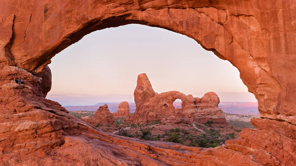
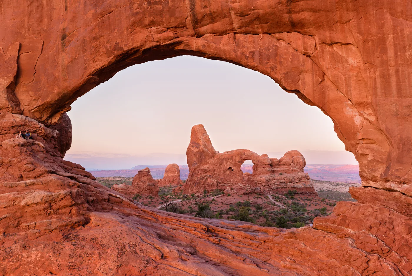
Featured photograph: Turret Arch framed by the North Window in Arches National Park. Thomas Wolf, www.foto-tw.de, CC BY-SA 3.0; this cropped and compressed adaptation uses the same license. Source and license record. Photos have been cropped and compressed for this guide; they illustrate landscapes and do not show live conditions.
Pingback: 25 Best National Parks in USA (2026): Map & Planning Guide
Pingback: 7-Day Las Vegas & Grand Canyon Itinerary | DayZora