
Last route information reviewed: September 26, 2026. Updated September 26, 2026. Research-based planning guidance for DayZora.
A Route 66 road trip works best as a series of short historic-road explorations connected by practical travel days. This guide follows the Chicago-to-Santa Monica corridor through Illinois, Missouri, Kansas, Oklahoma, Texas, New Mexico, Arizona and California. It provides a fourteen-day moving itinerary and a slower twenty-one-day approach, with a numbered map, overnight towns, worthwhile stops and the distinctions needed to navigate the road as it exists today.
Route 66 is not one continuous modern U.S. highway that you can follow from a single navigation instruction. Historic alignments changed, some sections survive as local roads, and modern interstates connect many of the towns. The checked main-route calculation here is about 2,208 miles; a trip following more historic sections and side visits will be longer, often closer to the roughly 2,400-mile historic-road idea. Use the daily figures as transfer baselines rather than a claim to have measured every old alignment. Arrive in Chicago before the first road day and allow time after the finish for returning a car and traveling home.
Route: Route 66 corridor · Eight states
Start: Chicago · End: Santa Monica
Approximate distance: 2,208 miles for the modern connecting itinerary; historic alignments add distance. Approximate driving time: 41 hours before stops or delays.
Recommended trip length: 14–21 days · Best season: April–May; September–October
Major stops, in order: Chicago → Pontiac → Springfield IL → St Louis → Springfield MO → Galena KS → Tulsa → Oklahoma City → Elk City → Shamrock → Amarillo → Tucumcari → Albuquerque → Gallup → Holbrook → Flagstaff → Seligman → Peach Springs → Kingman → Needles → Barstow → San Bernardino → Santa Monica
Road type: Historic alignments plus modern connections · Best for: History and roadside culture
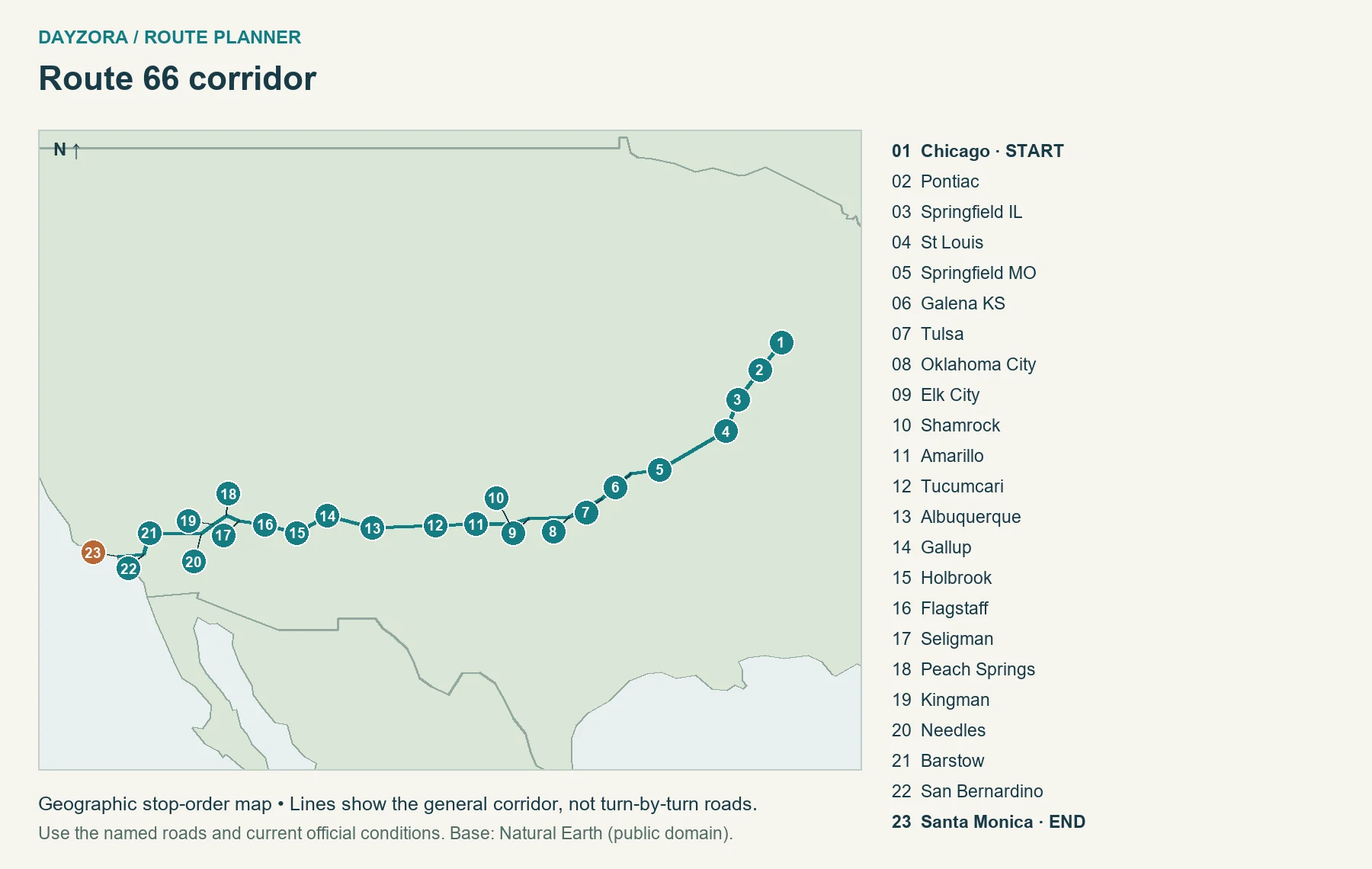
How to read distances and maps: Town-to-town distances and driving baselines were checked against OpenStreetMap-based OSRM routing on September 26, 2026, with official road mileage used where identified. They are approximate, exclude traffic and sightseeing, and can include town access or spurs; they are not always the same as a designated byway’s published length. Maps show geographic stop order, not exact road alignments or live closures. Add travel to the start, the return journey, and optional side trips. Recommendations for days, bases and pacing are DayZora’s editorial planning choices, not claims of a personally tested drive.
Choose the historic road deliberately
A fast Chicago-to-Santa Monica route and a historic Route 66 journey are different products. The first tries to minimize travel time; the second spends time on town streets, preserved road segments, museums and roadside businesses. The National Park Service’s Route 66 itinerary is useful for identifying historic places, while current state road reports establish whether a particular road is open.
- Historic alignment: a road used by Route 66 during a particular period. There may be several legitimate alternatives in one area.
- Preserved or signed section: a surviving road or town corridor you can choose to explore, subject to access and vehicle restrictions.
- Modern connection: an interstate or other practical highway joining the selected towns. It makes the trip feasible but does not reproduce every historic mile.
Save the actual historic stops as waypoints. Otherwise, a navigation app may quietly remove the old-road excursion. Before each day, inspect the planned route and keep an offline copy. Do not turn onto an unpaved or closed remnant simply because it carries a historic association.
Current access issue: California’s desert historic road
San Bernardino County’s National Trails Highway page identifies the Cadiz Road–Mountain Springs Road section as closed and warns about bridge restrictions and flood damage. Its separate Bridge 77 history records a March 2024 reopening, so an old closure paragraph alone is not a current status report. Use the county’s current closure listings and Caltrans QuickMap before any historic-road detour.
The main itinerary therefore uses the modern I-40 connection between the Needles and Barstow areas. Amboy, Oatman and other alternative historic-road excursions require their own checked plan and additional mileage. If I-40 itself is disrupted, do not assume the parallel old road provides an open bypass.
A practical 14-day Route 66 itinerary
This is fourteen road days, plus arrival and departure time. It makes forward progress every day; choose twenty-one days if you want several non-driving days or extensive historic-alignment exploration. The figures below are approximate modern-connection baselines between mapped waypoints. Attraction access, old-road detours, meals, traffic and sightseeing add time. Rounded daily times should not be treated as a promise that every historic stop fits.
| Day | Route and overnight | Approx. miles / driving hours | Plan |
|---|---|---|---|
| 1 | Chicago → Springfield IL Stay: Springfield IL |
205 miles / 4.5 hours | Pontiac museum stop, then Springfield; arrive in Chicago before this itinerary begins. |
| 2 | Springfield IL → St Louis Stay: St Louis |
96 miles / 2 hours | A short transfer leaves time for an Illinois historic-road stop and a St. Louis evening. |
| 3 | St Louis → Springfield MO Stay: Springfield MO |
216 miles / 4.5 hours | Select a Missouri stop such as Cuba; keep major museum time separate from the longest driving leg. |
| 4 | Springfield MO → Tulsa Stay: Tulsa |
194 miles / 4 hours | Make Galena the Kansas anchor; add Riverton and Baxter Springs as a deliberate historic-road excursion. |
| 5 | Tulsa → Oklahoma City Stay: Oklahoma City |
106 miles / 2 hours | Explore Tulsa before continuing; Chandler and Arcadia are optional historic-road stops with extra time. |
| 6 | Oklahoma City → Elk City Stay: Elk City |
111 miles / 2.5 hours | Choose a Route 66 museum around Clinton or Elk City rather than attempting every collection. |
| 7 | Elk City → Amarillo Stay: Amarillo |
150 miles / 3 hours | Pause at Shamrock before Amarillo; avoid scheduling the whole day around an unverified café opening. |
| 8 | Amarillo → Tucumcari Stay: Tucumcari |
113 miles / 2 hours | A short transfer allows time for Amarillo sights and Tucumcari neon after arrival. |
| 9 | Tucumcari → Albuquerque Stay: Albuquerque |
177 miles / 3.5 hours | Continue to Albuquerque; Santa Fe is an alternative older-alignment detour, not included in this mileage. |
| 10 | Albuquerque → Holbrook Stay: Holbrook |
234 miles / 4.5 hours | Use Gallup as a meaningful stop; this is one of the longer transfer days. |
| 11 | Holbrook → Flagstaff Stay: Flagstaff |
90 miles / 2 hours | A short drive gives time for Holbrook and Flagstaff; a national park side trip needs additional mileage. |
| 12 | Flagstaff → Kingman Stay: Kingman |
163 miles / 3.5 hours | Follow the selected preserved corridor through Seligman and Peach Springs toward Kingman. |
| 13 | Kingman → Barstow Stay: Barstow |
206 miles / 4 hours | Travel through Needles using the modern I-40 connection toward Barstow; do not assume the desert historic road is open throughout. |
| 14 | Barstow → Santa Monica Stay: Santa Monica |
146 miles / 3 hours | Continue through San Bernardino toward Santa Monica. Allow substantial urban traffic time and stay overnight before flying. |
On the longer Missouri and New Mexico transfer days, select fewer stops. On shorter days, spend the extra hours in one place instead of extending the night’s destination. Booking every motel with a late arrival expectation makes the itinerary fragile when a museum visit, roadwork or conversation takes longer than planned.
Route 66 by state: worthwhile stops and useful bases
1. Illinois
Route progression: Chicago → Pontiac → Springfield → St. Louis approach.
Start with a city day before collecting the car if possible. Route 66’s Chicago signs and alignments have changed over time, so choose the specific historic starting point you want to see instead of treating a navigation app’s city-center pin as the original highway endpoint. The first road day should leave room for town streets and a museum rather than immediately aiming for Missouri.
Stops to consider: Pontiac’s Illinois Route 66 Hall of Fame & Museum provides a useful introduction. Springfield adds a broader Illinois history stop; the Cozy Dog Drive In is a researched regional food option, with its current hours checked directly before travel. Litchfield’s Ariston Café is another historic-road possibility on the way south.
Pacing, stays and food: Stay in Springfield, then St. Louis. Use the shorter second day to add one historic stop without overloading the first. The I-55 connection makes efficient progress, but signed old-road sections require deliberate exits. Official state or route planning source.
2. Missouri
Route progression: St. Louis → Cuba area → Springfield, Missouri → Kansas approach.
The landscape becomes hillier and more wooded after the Mississippi crossing, and the road-trip experience shifts from large-city arrival to smaller communities and Ozark scenery. Do not confuse Springfield, Missouri, with the Illinois overnight town; label both clearly in your bookings and navigation notes.
Stops to consider: Cuba’s outdoor murals offer a walkable reason to stop along the route. St. Louis is worth an arrival evening or a full extra day if museums or the riverfront matter to you. The historic Chain of Rocks Bridge is a walking/cycling attraction, not the car crossing for this itinerary. The operator reports no Illinois-side access from June 22 through early October 2026 because of canal-bridge construction; check the Missouri-side park arrangements separately.
Pacing, stays and food: Stay in St. Louis and Springfield, Missouri, using local barbecue or casual town dining as flexible meal choices. The modern I-44 connection is the transfer baseline; old alignments and side attractions add time. A twenty-one-day trip can break this leg around Cuba or Rolla. Official state or route planning source.
3. Kansas
Route progression: Galena → Riverton → Baxter Springs.
Kansas contains only a short portion of historic Route 66, but skipping it would miss one of the road’s eight states. The point is to get off the through-highway and spend time in the communities, not simply cross a state line at speed. This is a manageable historic-road excursion within the Springfield-to-Tulsa day.
Stops to consider: Galena anchors the mapped route. The state tourism guide also identifies Riverton, Baxter Springs and the Rainbow Bridge as relevant stops. Check local access and opening hours for the specific places you choose, and respect the fact that historic buildings may have active businesses or private uses.
Pacing, stays and food: Take a town café break and continue to Tulsa for the night, or add a local overnight if you want museum time. The day-table mileage uses Galena as its required waypoint; completing the broader Kansas historic section adds local miles and should be entered separately into navigation. Official state or route planning source.
4. Oklahoma
Route progression: Tulsa → Chandler/Arcadia options → Oklahoma City → Clinton/Elk City.
Oklahoma deserves short driving days because its Route 66 interest is spread among roadside buildings, museums and communities. The most useful planning decision is which museum to visit deeply, rather than how many museum names to check off. Tulsa and Oklahoma City also make practical places to pause for laundry, groceries or a non-driving day.
Stops to consider: Consider Chandler’s Route 66 Interpretive Center, Arcadia’s Round Barn, the Oklahoma Route 66 Museum in Clinton or the National Route 66 Museum Complex in Elk City. These are choices along the broader corridor, not all mandatory stops in the calculated baseline. The Round Barn’s official site notes volunteer operation, a reason to verify hours before relying on an interior visit.
Pacing, stays and food: Stay in Tulsa, Oklahoma City and Elk City in the fourteen-day plan. Look for onion burgers or other local diner food, with a picnic backup. If you add a stop such as the Threatt Filling Station, use it to learn about the unequal conditions faced by Black motorists, not merely as a photo backdrop. Official state or route planning source.
5. Texas
Route progression: Shamrock → Amarillo → western Panhandle.
The Texas Panhandle supplies broad horizons and longer open-road stretches, but the strongest stops are concentrated in towns. Wind and heat can change how pleasant an outdoor stop feels. Keep a water supply and avoid treating a long straight road as permission to extend a tiring driving day.
Stops to consider: Shamrock’s Tower Station and U-Drop Inn is a distinctive historic building. Amarillo adds its historic Route 66 district and the separate Cadillac Ranch art installation west of town. Cadillac Ranch is a modern roadside attraction associated with the trip, not a surviving 1926 highway facility.
Pacing, stays and food: Stay in Amarillo, using its restaurants and groceries before the next transfer. Barbecue, burgers or a diner meal fit the region without requiring a particular restaurant reservation. If you want to visit an attraction outside the mapped town center, add the access miles rather than assuming they are part of the baseline. Official state or route planning source.
6. New Mexico
Route progression: Tucumcari → Albuquerque → Gallup.
New Mexico changes the journey’s scale again, with open high country, mesas, town neon and a strong sense of the road’s different eras. Tucumcari is worth an overnight because arriving after a long drive and leaving immediately misses the slower town experience. Albuquerque is the best point in this schedule for a full non-driving day on a longer trip.
Stops to consider: The Blue Swallow Motel is a documented historic landmark in Tucumcari; it is also accommodation, so respect guests and ask before entering private areas. Albuquerque’s Central Avenue corridor gives the route an urban chapter. Santa Fe belonged to an earlier alignment before the 1937 rerouting; it is an optional route choice with extra nights and miles.
Pacing, stays and food: Stay in Tucumcari and Albuquerque, then use Gallup as a stop or an extra overnight before Arizona. Try New Mexican chile dishes according to your heat preference. Tribal communities are living communities: verify visitor access and photography permissions directly, and do not assume every site is open for casual drop-in sightseeing. Official state or route planning source.
7. Arizona
Route progression: Holbrook → Flagstaff → Seligman → Peach Springs → Kingman.
Arizona combines high-desert towns, the cooler Flagstaff area and a valuable preserved-road section west of Seligman. The marked route through Peach Springs deliberately adds historic-road time instead of letting a fast planner remain entirely on I-40. Landscape and temperature change substantially with elevation.
Stops to consider: Use Holbrook for a town stop, Flagstaff for a walkable overnight base, then take the Seligman–Peach Springs–Kingman corridor. Kingman’s Arizona Route 66 Museum is a useful researched option. Oatman and the winding Sitgreaves Pass road are a separate historic alignment choice; they are not included in this guide’s main mileage.
Pacing, stays and food: Stay in Holbrook, Flagstaff and Kingman, using town diners and groceries before remote sections. A Grand Canyon or Petrified Forest visit is an additional national-park plan, not a quick included roadside stop. Check park access, fees and the extra driving before adding one. Winter weather can affect Flagstaff even when low desert towns are warm. Official state or route planning source.
8. California
Route progression: Needles → Barstow → San Bernardino → Santa Monica.
The final state crosses desert before reaching a large urban region. Those are two different driving challenges: heat and limited services in one, traffic and frequent decisions in the other. Keep the last day free of a fixed departure flight so the finish does not become a race through Los Angeles.
Stops to consider: Needles’ El Garces connects the road corridor with earlier railway travel. Barstow and San Bernardino divide the approach to the city. In Santa Monica, distinguish the historic highway endpoint at Lincoln and Olympic boulevards from the commemorative “End of the Trail” sign at the pier, as explained by Santa Monica’s tourism office.
Pacing, stays and food: Stay in Barstow before the final urban leg, then Santa Monica or a suitable Los Angeles base. Use town meals and refill supplies before desert travel. This plan uses modern connections between Needles and Barstow; it does not send readers along every mile of National Trails Highway. Official state or route planning source.
How to turn the route into a 21-day trip
Use the same westbound spine, then place seven additional days where they change the experience. The following allocation keeps the trip coherent without automatically adding hundreds of unrelated detour miles.
- Chicago: add a full city day before the first road transfer, with the car collected only when useful.
- Illinois: add an overnight around Pontiac or a second Springfield night for museum time.
- Missouri: split the St. Louis–Springfield leg with a smaller-town overnight, or give St. Louis a full day.
- Oklahoma: add a full day in Tulsa or Oklahoma City and choose one additional historic-road museum.
- New Mexico: add an Albuquerque rest day. Alternatively, use this time toward a separately mapped Santa Fe alignment excursion, which may need another night.
- Arizona: add time around Flagstaff or Kingman for a checked historic-road outing. A major national-park detour should replace other plans or extend the trip further.
- Santa Monica: keep a full finish day before departure, so traffic cannot steal the endpoint experience.
These extra days are not all museum days. Laundry, groceries, a walk and an early dinner can be valuable after repeated hotel changes. If the route is a shared trip, agree in advance how much time each person wants in the car, at historic sites and in cities.
Best time for a Route 66 road trip
Spring and early autumn are useful overall planning windows, but the route crosses too much country for one weather rule. The Midwest and Plains can have severe storms; the Southwest can be hot; higher-elevation New Mexico and Arizona can be cold or snowy. Check the forecast for the next overnight town and the highest part of the next drive, not only the starting city.
Summer offers long daylight and school-holiday convenience, but desert stops require water and realistic heat-aware activity plans. Winter can reduce flexibility on the high-country portion and shorten the sightseeing day. For 2026’s centennial, verify specific event dates and lodging availability with the host community rather than assuming every celebration lasts all year.
Choose accommodation for the route you will actually drive
Historic motels can be a memorable part of the journey, but a recognizable sign does not establish current availability, room condition or facilities. Read current property information and book directly or through a reputable booking service. Confirm parking, arrival arrangements, cancellation terms and any accessibility needs before treating a motel as a fixed anchor.
Mix small-town stays with larger service bases. Springfield, Tulsa, Oklahoma City, Albuquerque, Flagstaff and Kingman can simplify groceries, laundry and vehicle needs. An extra fifteen-minute evening drive to a cheaper room may cost more in fatigue than it saves; compare the full day’s route. Our travel budget guide helps organize those tradeoffs.
Food stops without a rigid reservation chain
Let food reflect the region: Illinois diner traditions, Missouri barbecue, Oklahoma onion burgers, Texas Panhandle meals and New Mexican chile are useful starting points. Choose one priority meal per day and keep the others flexible. Small businesses may have limited days or hours, and a famous historic café is not necessarily open when you arrive.
Carry water and a modest supply of groceries, especially before the desert sections. A picnic also protects the day when a museum visit runs long. Historic-road businesses are often small: park considerately, ask before photographing private interiors, and avoid treating customers or residents as part of an attraction.
Vehicle, navigation and road-day habits
A regular passenger car suits the paved main route. An RV or trailer requires a separate check of parking, bridge limits, narrow historic roads and overnight facilities. Keep the vehicle’s actual dimensions and weight available rather than relying on the rental category name. Do not assume that a historic bridge permits every vehicle that can physically fit.
Inspect tires and basic vehicle needs before leaving Chicago and keep the next service stop practical. Download maps before remote sections, keep enough fuel or charge to reach a verified alternative, and stop when tired. For current alerts, use the relevant state transportation service rather than social posts or an old guidebook.
If a cross-country route feels too ambitious, select one state’s historic section and allow time to return. Compare DayZora’s other U.S. road-trip routes for shorter regional options. At the western end, the California itinerary guide provides a separate coastal extension; it adds days and is not included here.
Estimate fuel and the whole-trip budget
Estimated fuel cost = total miles ÷ vehicle MPG × fuel price per gallon. For example, a hypothetical 600-mile trip in a vehicle achieving 30 MPG at an assumed $4 per gallon costs about $80 in fuel. The price is an illustration, not today’s local pump price. Include the return drive, local outings and a sensible detour allowance in total miles.
| Expense | Planning amount |
|---|---|
| Fuel or charging | Your route calculation; for EVs use expected kWh and actual charging tariffs. |
| Accommodation | Number of nights × quoted total nightly price, including applicable taxes and fees. |
| Food | Travelers × days × your own daily allowance; include groceries and planned restaurant meals. |
| Attractions and parks | Current admission, reservation and tour charges for the sites you will actually visit. |
| Parking and tolls | Hotel and city parking, toll roads, bridges and rental-company toll processing where applicable. |
| Miscellaneous | Rental costs if relevant, supplies and a contingency you can afford. |
A park pass does not automatically cover campground, tour or timed-entry charges. Check current NPS pass eligibility and prices, including residency-related differences. Use DayZora’s travel budget guide to compare the complete trip rather than only the room rate.
Before you leave: roads, vehicle and packing
Review the state transportation service and the relevant park’s alerts before booking a tightly timed route, again before departure, and each morning in mountain or storm-affected country. A route planner’s line does not establish that a road is open. Leave a comfortable arrival margin and stop when tired; a shorter itinerary is better than recovering lost time after dark.
For an EV, use the U.S. Department of Energy station locator and your vehicle or network planner to check connector compatibility, operating status, charging speed and an alternative stop. Do not infer charging access from a town’s size. Remote stretches need an energy reserve; charging time is additional to driving time.
- Documents: valid driver’s license, registration, insurance details and rental documents if applicable.
- Vehicle: tires and pressure, required fluids, lights, and a spare or repair solution appropriate to the vehicle; know how to request roadside assistance.
- Personal supplies: drinking water, snacks, medication, sun protection and layers suitable for elevation changes.
- Technology: car charger, charging cables, power bank and downloaded maps; share the route with someone if coverage will be limited.
- Emergency supplies: a practical vehicle kit and weather-appropriate equipment; follow local chain or traction requirements rather than improvising.
For the rest of your luggage, use the travel packing checklist. The broader travel tips guide covers booking and preparation decisions that apply before you collect the car.
Route 66 road-trip FAQs
How long does Route 66 take?
Allow fourteen moving days for this selective corridor itinerary, plus arrival and departure. Twenty-one days provides more historic-road time and rest. Extensive detours require longer.
Where does Route 66 start and end?
The classic journey begins in Chicago and finishes in Southern California. In Santa Monica, the historic highway endpoint is Lincoln and Olympic; the pier’s sign is a commemorative finish used by many travelers.
Can I still drive the historic road?
Many sections survive, but it is not one continuous modern U.S. highway. Choose preserved alignments and use modern connections where appropriate, with current closure checks.
Which eight states does it cross?
Illinois, Missouri, Kansas, Oklahoma, Texas, New Mexico, Arizona and California, in westbound order.
Why is this guide’s mileage below about 2,400 miles?
The 2,208-mile calculation joins selected towns with modern roads and one chosen Arizona historic section. Following more old alignments, attractions and side trips increases the distance. Different historical alignments also have different lengths.
Is Santa Fe on Route 66?
It was part of an earlier New Mexico alignment before the 1937 rerouting. This main itinerary uses the more direct Tucumcari–Albuquerque corridor; a Santa Fe excursion needs its own mileage and time.
Should I book every night ahead?
Reserve the stays that matter most and check cancellation terms. Busy events and limited historic properties favor advance booking, while some flexibility helps when weather or a longer stop changes the pace.
Pingback: 25 Best Road Trips in the USA: Routes & Maps for 2026