
Last route information reviewed: September 26, 2026. Updated September 26, 2026. Research-based planning guidance for DayZora.
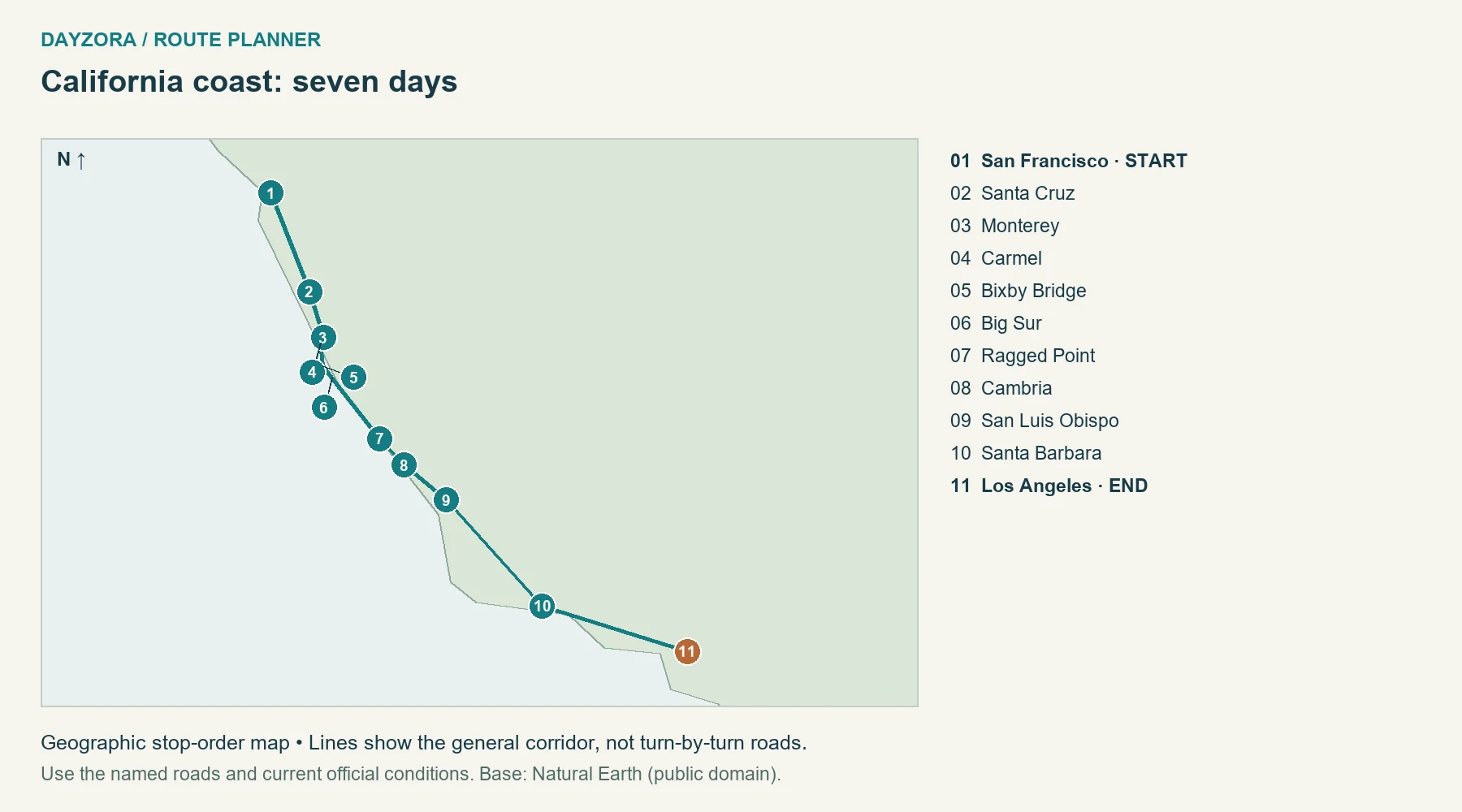
This California road trip follows a practical southbound route from San Francisco through Monterey, Big Sur, Cambria and Santa Barbara to Los Angeles. With ten days, it continues to San Diego; with fourteen, it adds Yosemite Valley before returning to the coast. The three options change both geography and pace, so you can choose a trip that fits your time instead of squeezing the same wish list into fewer days.
The guide includes numbered route maps, approximate driving distances, day-by-day overnight bases, meal-planning advice and a Highway 1 fallback. It is designed for travelers using a normal passenger car and staying in towns or reserved accommodation. The seven-day version is a coast-focused introduction, not a tour of the entire state. The longer versions still leave out places that would create major detours. Distances cover the main transfers, while city sightseeing, optional park roads, airport access and your journey home add more. Current Caltrans and National Park Service information should guide any final booking decisions.
For a detailed morning-to-evening schedule on the one-week coastal route, use our 7-day California itinerary. It expands the overnight plan into daily sightseeing, meals, booking priorities and departure-day timing.
Start: San Francisco.
End: Los Angeles in 7 days; San Diego in 10 or 14.
Main-route mileage / driving baseline: about 443 miles / 10 hours; 563 miles / 12.5 hours; or 855 miles / 19 hours.
Best season: late spring or early autumn for a mixed coast-and-valley trip, subject to weather, smoke and road access.
Roads: paved highways and urban streets, with winding Highway 1 through Big Sur.
Best for: first-time California visitors who want a coherent route and time at each base.
Swipe sideways to read the full table on a phone.
| Option | Main route | What the extra time buys | Suggested use |
|---|---|---|---|
| 7 days | San Francisco → Monterey → Big Sur → Cambria → Santa Barbara → Los Angeles | A focused coastal introduction | Choose this if you can leave Yosemite and San Diego for another trip. |
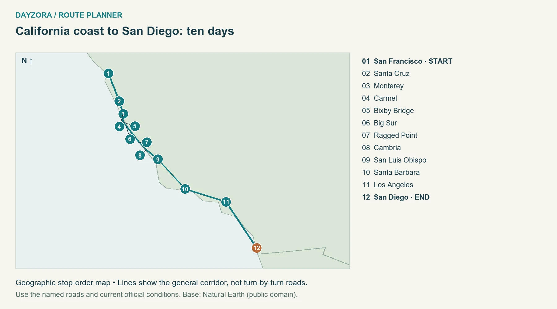
| 10 days | Seven-day corridor, then San Diego | An extra San Francisco day, more Los Angeles time and a southern endpoint | A stronger fit for city-and-coast variety. |
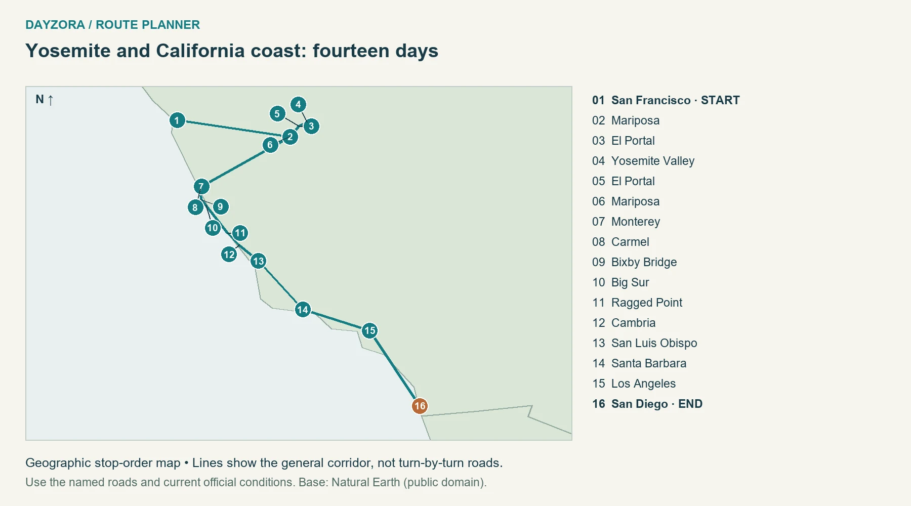
| 14 days | San Francisco → Yosemite via Mariposa/El Portal → Monterey → coast → San Diego | Two full Yosemite days and more southern-city time | Choose this if mountains are an actual priority, with a smoke/closure backup. |
How to read distances and maps: Town-to-town distances and driving baselines were checked against OpenStreetMap-based OSRM routing on September 26, 2026, with official road mileage used where identified. They are approximate, exclude traffic and sightseeing, and can include town access or spurs; they are not always the same as a designated byway’s published length. Maps show geographic stop order, not exact road alignments or live closures. Add travel to the start, the return journey, and optional side trips. Recommendations for days, bases and pacing are DayZora’s editorial planning choices, not claims of a personally tested drive.
Check Highway 1 and Yosemite before fixing the route
The Caltrans Highway 1 report checked September 26, 2026 listed one-way traffic control at Rocky Creek Bridge, south of Monterey, rather than a full Big Sur through closure. Allow for controlled traffic and recheck the route before departure. The earlier Regents Slide reopening does not guarantee that later fires, slides or construction cannot interrupt the road.
If Big Sur closes: keep Monterey and Cambria as separate coastal bases. From the Monterey side, use signed connections to US 101, travel south inland, and return to the coast via an open state-highway connection such as CA 46. Recheck the actual diversion before departure. Do not use narrow mountain roads as an improvised through-route, and do not assume you can pass a closure by entering from the other end. Remove the full Big Sur crossing from that day’s plans.
Yosemite does not require a timed entrance reservation in 2026; admission, accommodation and activity bookings are separate. NPS’s September 25 conditions update listed Yosemite Valley roads and the Highway 140 approach open, but Glacier Point Road closed for smoke and firefighting operations. The fourteen-day plan therefore uses the valley and western approach, without Glacier Point or a Tioga crossing. Check current Yosemite conditions and air quality again. If smoke or closures make the park unsuitable, replace those nights with a slower coast itinerary.
Understand the driving before booking rooms
The core route uses modern connections between San Francisco and Santa Cruz; it does not promise Highway 1 for every northern mile. The essential coastal section is Monterey through Big Sur to Cambria. South of Cambria, the plan uses San Luis Obispo and US 101 toward Santa Barbara, then practical roads to Los Angeles. Los Angeles to San Diego is a separate urban-highway transfer, not a continuous oceanfront scenic drive.
Swipe sideways to read the full table on a phone.
| Transfer | Approx. main-route miles | Baseline driving allowance | What changes the day |
|---|---|---|---|
| San Francisco → Santa Cruz → Monterey | 116 | 2.5–3 hours | Bay Area traffic and any extra coastal detour. |
| Monterey → Carmel → Big Sur → Cambria | 104 | 3 hours | Pullouts, walks, meals and one-way traffic control make this a full sightseeing day. |
| Cambria → San Luis Obispo → Santa Barbara | 128 | 3 hours | Town stops and beach detours are extra. |
| Santa Barbara → Los Angeles | 95 | 2–3 hours | Heavy traffic can make the same distance much slower. |
| Los Angeles → San Diego | 120 | 2.5–4 hours | Departure time, congestion and your exact hotel locations. |
| San Francisco → Mariposa → El Portal → Yosemite Valley | 211 | 4.5–6 hours | Entrance queues, mountain driving and roadwork. |
| Yosemite Valley → El Portal → Mariposa → Monterey | 198 | 4.5–6 hours | A transfer day; do not add a long park hike first. |
These are planning ranges around checked routing baselines, not guaranteed arrival times. Overnight locations within each city can change mileage substantially. Keep flights and prepaid tours away from the end of your longest transfer.
7-day California road trip: concentrate on the coast
Arrive in San Francisco before day one if possible. This version uses six nights along the route and a final Los Angeles day; an early flight on day seven would remove that sightseeing time. It gives Monterey two nights, which keeps the Big Sur day from starting with a long approach. There is no Yosemite or San Diego detour.
Swipe sideways to read the full table on a phone.
| Day | Plan and driving | Sleep |
|---|---|---|
| 1 | Explore one or two San Francisco neighborhoods on foot or transit. Delay collecting the car if you do not need it in the city. | San Francisco |
| 2 | Collect the car, travel via Santa Cruz to Monterey, and keep the afternoon for the waterfront. About 116 transfer miles. | Monterey or Carmel |
| 3 | Use the day for Monterey and Carmel: choose one major indoor visit or a locally checked coastal walk. Keep the same room. | Monterey or Carmel |
| 4 | Drive the 104-mile Big Sur corridor in daylight. Choose a few legal viewpoints and one short stop rather than a packed timetable. | Cambria |
| 5 | Continue through San Luis Obispo to Santa Barbara, about 128 miles. Leave time to walk at the destination. | Santa Barbara |
| 6 | Travel to Los Angeles, about 95 miles, and explore near your chosen base rather than crossing the whole city. | Los Angeles |
| 7 | A local Los Angeles day or departure day. Budget airport access and rental return separately. | Los Angeles if extending |
The tradeoff is limited city time. If San Francisco museums or Los Angeles attractions are your main reason for coming, shorten the coast or use ten days. Do not turn day four into a race to Los Angeles: Cambria is the useful stopping point that protects the coastal experience.
10-day California road trip: cities, coast and San Diego
Three extra days change the trip’s endpoint and give the cities room. This version adds a full San Francisco day, a full Los Angeles day and the San Diego transfer/end stay. It still avoids an inland mountain detour, making it easier to adapt if the coast is your main interest.
Swipe sideways to read the full table on a phone.
| Day | Plan | Sleep |
|---|---|---|
| 1 | Arrive or explore San Francisco without a long driving commitment. | San Francisco |
| 2 | A full San Francisco day: choose a neighborhood walk and a booked attraction if desired. | San Francisco |
| 3 | Drive via Santa Cruz to Monterey; leave the late afternoon open. | Monterey/Carmel |
| 4 | A second Monterey Bay day, keeping the same base. | Monterey/Carmel |
| 5 | Daylight Big Sur crossing to Cambria, subject to the live road report. | Cambria |
| 6 | San Luis Obispo stop, then Santa Barbara with time for the waterfront. | Santa Barbara |
| 7 | Transfer to Los Angeles and explore close to the hotel. | Los Angeles |
| 8 | A full Los Angeles day focused on one area or one major attraction. | Los Angeles |
| 9 | Drive to San Diego; avoid a fixed-time activity immediately after arrival. | San Diego |
| 10 | A San Diego neighborhood, waterfront or beach day, with departure time accounted for. | San Diego if extending |
Use the southern extension for a different city experience, not a checklist of every beach between Los Angeles and San Diego. A major theme-park day replaces another day’s activities and may justify another night; it is not a small stop to add to the transfer.
For park-specific walks, gateway stays and current access notes, see the Yosemite and Sequoia sections of our U.S. national parks guide. Our summer parks guide also explains high-country snow and seasonal road planning.
14-day California road trip: add Yosemite Valley first
This version heads inland from San Francisco before turning west to Monterey. That creates one substantial mountain visit rather than repeated coast-to-mountain zigzags. Reserve three nights in or near Yosemite for an arrival evening and two full days, then dedicate a separate day to the coast transfer. The route returns through the western approach and does not depend on Tioga Road being open.
Swipe sideways to read the full table on a phone.
| Day | Plan | Sleep |
|---|---|---|
| 1 | San Francisco arrival and an easy local outing. | San Francisco |
| 2 | Full city day; finalize road and park checks before collecting the car. | San Francisco |
| 3 | Drive about 211 miles through Mariposa and El Portal to Yosemite Valley. Treat this as a transfer day. | Yosemite Valley or El Portal |
| 4 | A valley-focused day with short walks and current ranger information. Park once where possible. | Same Yosemite-area base |
| 5 | A second valley day, choosing activities that fit current trail access, smoke and personal ability. | Same Yosemite-area base |
| 6 | Return via El Portal and Mariposa, then drive to Monterey, about 198 miles. Do not add a long morning hike. | Monterey/Carmel |
| 7 | Monterey Bay and Carmel at a relaxed pace. | Monterey/Carmel |
| 8 | Big Sur daylight crossing to Cambria, or the checked US 101 alternative. | Cambria |
| 9 | San Luis Obispo and Santa Barbara. | Santa Barbara |
| 10 | Transfer to Los Angeles; keep the afternoon local. | Los Angeles |
| 11 | A full Los Angeles day without another hotel change. | Los Angeles |
| 12 | Drive to San Diego and settle into the final base. | San Diego |
| 13 | A full San Diego day with a single main activity. | San Diego |
| 14 | A final local morning if departure allows; return the car with a generous margin. | Departure or extension |
Coastal replacement for Yosemite: if the park is unsuitable, allocate day three to Santa Cruz, days four and five to the Monterey area, and keep day six as a flexible coastal day before rejoining the remaining schedule. This changes both the route and mileage; recalculate rather than retaining the 855-mile figure. Extra time in one place is a useful contingency, not a failed itinerary.
Where to stay, eat and spend the extra hours
San Francisco and Santa Cruz
Choose a San Francisco base around the activities you actually want to do, then consider collecting the car as you leave. Hotel parking and navigating steep streets can make a car inconvenient during a city stay. Santa Cruz works as a stop on the way to Monterey; if you want a substantial beach or boardwalk visit, make it an overnight rather than pretending it is only a lunch break. Check the attraction’s current operating schedule before planning around it.
Use neighborhood cafés and groceries to prepare for the first moving day. A cooler or insulated bag can reduce dependence on finding a restaurant at the exact moment you reach a viewpoint. Avoid leaving bags visible in the parked car.
Monterey, Carmel and the Big Sur crossing
Monterey offers practical services and a waterfront base; Carmel suits travelers who want village time and nearby coastal access. Compare the complete parking and accommodation cost. A second night is valuable because it gives you time to explore before a road day that deserves daylight.
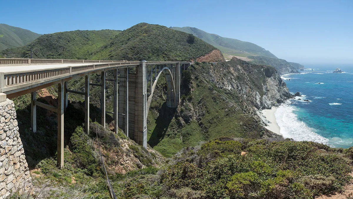
Eat before leaving the more developed area, carry water and a planned lunch, and confirm any restaurant stop in the Big Sur area directly. Do not assume there are frequent services throughout the crossing. Bixby Creek Bridge is a landmark to view from permitted parking, not a place to stop in the traffic lane. For broader landscape comparisons, see the scenic road-trip guide.
Cambria, San Luis Obispo and Santa Barbara
Cambria gives you a useful overnight immediately after the winding coastal section. Spend the evening locally instead of extending the drive simply because a map shows relatively few miles remaining. San Luis Obispo is a practical inland town stop before US 101 continues toward Santa Barbara.
Santa Barbara works best when you arrive early enough to park and walk. Choose lodging with a clear parking arrangement, then use the waterfront or town center for a relaxed meal. Regional seafood, produce-focused meals and casual cafés are flexible choices; exact menus and prices should come from the business you choose. If you add a winery, arrange a driver who will not drink.
Los Angeles and San Diego
Los Angeles needs a neighborhood decision before a hotel decision. Choose a base near the activities that matter most, whether that is the west side, central museums or another area, and avoid repeatedly crossing the city. A nominally short distance can consume much of a day in traffic. Reserve one main attraction per full day, then add nearby options only if time remains.
San Diego adds a separate southern base rather than a rushed day trip from Los Angeles. Stay near your preferred waterfront, city or beach activities, and account for parking. Tacos, seafood and neighborhood dining can fit an unstructured evening without requiring another long drive. Compare these bases with DayZora’s weekend getaway destinations if you are considering a shorter city stay instead.
Yosemite Valley, El Portal and Mariposa
In-valley lodging reduces daily approach driving but requires availability and a budget that works for you. El Portal is a western gateway alternative. Mariposa has more of a town setting, but staying there adds a meaningful drive into the valley each day; the transfer mileage above does not include repeated commuting.
Keep food storage consistent with park rules, verify dining availability, and carry a picnic for a day that may include parking delays. Choose walks through current NPS advice, not a generic list of famous hikes. The base itinerary does not require Half Dome, a wilderness permit or a strenuous summit; adding any such activity needs separate planning.
When to go and what to leave out
Late spring can combine moderate coastal weather with a worthwhile Yosemite Valley visit, but high-elevation access remains seasonal. Summer brings long days and busy accommodation, while coastal fog and inland heat create very different conditions on the same trip. Early autumn can work well, but wildfire smoke may alter the mountain portion and daylight gets shorter. Winter is a different plan requiring weather-aware mountain access rather than assuming the fourteen-day version works unchanged.
Do not add Death Valley, Lake Tahoe, far-northern redwoods and multiple national parks to these schedules simply because they are in California. Each requires a meaningful route change. Choose the experience that matters most and give it enough nights. For other regions and trip lengths, use the 25-route U.S. planning guide.
Rental-car and booking decisions
Compare one-way rental quotes from the actual pickup and return locations before buying flights. Check taxes, parking, toll handling, additional drivers and any drop charge in the quote; no universal one-way fee applies to every booking. A compact vehicle can make urban parking easier, while an RV changes road, campsite and parking choices substantially.
Book the least flexible accommodation first, usually the park or a limited coastal base, then fit the rest of the route around it. Keep cancellation terms visible in your planning notes. If a late arrival would put you on unfamiliar winding roads after dark, shorten the day’s stops or move the overnight base.
Estimate fuel and the whole-trip budget
Estimated fuel cost = total miles ÷ vehicle MPG × fuel price per gallon. For example, a hypothetical 600-mile trip in a vehicle achieving 30 MPG at an assumed $4 per gallon costs about $80 in fuel. The price is an illustration, not today’s local pump price. Include the return drive, local outings and a sensible detour allowance in total miles.
| Expense | Planning amount |
|---|---|
| Fuel or charging | Your route calculation; for EVs use expected kWh and actual charging tariffs. |
| Accommodation | Number of nights × quoted total nightly price, including applicable taxes and fees. |
| Food | Travelers × days × your own daily allowance; include groceries and planned restaurant meals. |
| Attractions and parks | Current admission, reservation and tour charges for the sites you will actually visit. |
| Parking and tolls | Hotel and city parking, toll roads, bridges and rental-company toll processing where applicable. |
| Miscellaneous | Rental costs if relevant, supplies and a contingency you can afford. |
A park pass does not automatically cover campground, tour or timed-entry charges. Check current NPS pass eligibility and prices, including residency-related differences. Use DayZora’s travel budget guide to compare the complete trip rather than only the room rate.
Before you leave: roads, vehicle and packing
Review the state transportation service and the relevant park’s alerts before booking a tightly timed route, again before departure, and each morning in mountain or storm-affected country. A route planner’s line does not establish that a road is open. Leave a comfortable arrival margin and stop when tired; a shorter itinerary is better than recovering lost time after dark.
For an EV, use the U.S. Department of Energy station locator and your vehicle or network planner to check connector compatibility, operating status, charging speed and an alternative stop. Do not infer charging access from a town’s size. Remote stretches need an energy reserve; charging time is additional to driving time.
- Documents: valid driver’s license, registration, insurance details and rental documents if applicable.
- Vehicle: tires and pressure, required fluids, lights, and a spare or repair solution appropriate to the vehicle; know how to request roadside assistance.
- Personal supplies: drinking water, snacks, medication, sun protection and layers suitable for elevation changes.
- Technology: car charger, charging cables, power bank and downloaded maps; share the route with someone if coverage will be limited.
- Emergency supplies: a practical vehicle kit and weather-appropriate equipment; follow local chain or traction requirements rather than improvising.
For the rest of your luggage, use the travel packing checklist. The broader travel tips guide covers booking and preparation decisions that apply before you collect the car.
California road-trip FAQs
Is seven days enough?
Yes for a focused San Francisco-to-Los Angeles trip with a few coastal bases. It is not enough to see all of California, and an early flight on the final day reduces sightseeing time.
Can I drive the coast in one week?
The central coastal route here is practical in a week when Highway 1 access allows it. Recheck Caltrans and keep an inland alternative; do not interpret a seven-day itinerary as a guarantee of an open through-road.
Should I drive north or south?
Either direction can work. Southbound puts many Pacific-side pullouts on your side through Big Sur, but flight prices, lodging and road conditions may matter more.
Do I need Yosemite reservations in 2026?
No timed entrance reservation is required for 2026. Lodging, camping and some activities have separate booking rules, and entrance fees still apply.
Does the fourteen-day route use Tioga Road?
No. It enters and leaves Yosemite through the western approach via Mariposa and El Portal. The planned visit is valley-focused and excludes the currently closed Glacier Point Road.
Can I do this with an electric vehicle?
Plan with your exact vehicle and network, verify compatible chargers and keep an alternative. Charging time and local mileage must be added to the driving baselines.
Is the route a loop?
No. The seven-day option ends in Los Angeles and the longer options in San Diego. Returning to San Francisco requires extra days and mileage or a separate transport arrangement.
Traveling west on a historic cross-country journey? Our Route 66 itinerary finishes in the Los Angeles area. Treat a California coast extension as additional travel days and recalculate the mileage and rental arrangements.
Pingback: 25 Best Road Trips in the USA: Routes & Maps for 2026
Pingback: 7-Day California Itinerary: Coast Route & Map | DayZora
Pingback: 10-Day USA Road Trip Itinerary: New England | DayZora