A pacific coast highway road trip is the single most iconic drive in America, and it earns that title on merit: 655 miles of cliffs, surf, redwoods, and sun-bleached coastal towns from Dana Point to Leggett. If you are planning one for the first time, the trick is not simply pointing the car north or south — it is knowing which stops are worth an overnight, where the road closures tend to hit, how many days you actually need, and how to drive it in the direction that puts the ocean on your side of the car. This guide gives you all of that: a mile-by-mile plan, day-by-day itineraries for 3, 5, and 10 days, the best stops ranked, real costs, road-closure strategy, and answers to the questions every first-timer asks.
Start with the basics. The Pacific Coast Highway is California State Route 1 (SR-1), running from Dana Point in Orange County to Leggett in Mendocino County. The world-famous stretch — the one in every photograph — is the 90-mile Big Sur section between San Simeon and Carmel, where the road clings to cliffs 300 feet above the Pacific. But limiting your pacific coast highway road trip to Big Sur alone means missing the elephant seals of San Simeon, the Danish bakeries of Solvang, the wine country of Santa Ynez, the art-deco sweep of Santa Barbara, the cliff paths of Mendocino, and the avenue of the giants in the redwoods. A complete pacific coast highway road trip covers all of them.
Which Direction Should You Drive the Pacific Coast Highway?
This is the most-asked question about any pacific coast highway road trip, and the answer is simple: drive north to south, starting near San Francisco (or Leggett) and ending near Los Angeles (or San Diego). Heading southbound puts your car on the ocean side of the road the entire way, which means unobstructed views, easy pullouts into scenic overlooks without crossing traffic, and safer stops. The cliffs drop away on your right; the mountains rise on your left. Northbound drivers hug the inland lane and must swing across traffic for every lookout — it is still beautiful, but noticeably less relaxed.
There are two legitimate exceptions. If you are flying into LAX and starting in Los Angeles, the logistics of driving north can be simpler and the trip is still spectacular — many travelers do exactly this and love it. And if your only goal is the Big Sur section, direction barely matters because you will likely drive it out and back from one end. But all else equal, north-to-south wins for the pure driving experience.
How Many Days Do You Need for a Pacific Coast Highway Road Trip?
You can technically drive the full 655 miles in two long days, but you should not. Here is a realistic breakdown of what different trip lengths actually get you:
| Trip length | What you get | Best for |
|---|---|---|
| 3 days | San Francisco to Los Angeles via Big Sur, the essential stops only | Long weekenders with a rental car and tight schedule |
| 5 days | Full SF-to-LA with overnights in Monterey, Cambria, and Santa Barbara | The classic first-timer trip |
| 7 days | SF to LA at a relaxed pace with a wine-country detour | Food and wine lovers |
| 10 days | Leggett to San Diego — the complete highway, redwoods to surf towns | The once-in-a-lifetime drive |
| 14 days | The full highway plus side trips: Yosemite, Channel Islands, Joshua Tree | Serious explorers with time |
Our recommendation for a first pacific coast highway road trip: five days from San Francisco to Los Angeles. It covers the Big Sur heart of the route without turning into a death march, and it leaves one buffer day for the thing nobody plans for — the road closure.
Pacific Coast Highway Road Closures: What You Must Check
Big Sur is geologically dramatic, and that drama has a price: landslides. Sections of Highway 1 through Big Sur close periodically, sometimes for months, after heavy rain or fire. Before you commit to a pacific coast highway road trip, check the Caltrans QuickMap or the Big Sur Chamber of Commerce road conditions page — do this again the week of your trip and the morning you leave. When a closure splits Big Sur in two (this has happened in 2023, 2024, and repeatedly since), travelers adapt by driving the open portion out and back from one end, or rerouting inland via Highway 101 or Nacimiento-Fergusson Road.
The best seasons for avoiding closures are late summer and early fall, when the hills have dried out. Winter brings the greenest hills and the fewest crowds but the highest closure risk. If a closure is in effect, do not despair: the southern Big Sur stretch from the south and the northern stretch from Carmel are each worth a full day on their own.
The 3-Day Pacific Coast Highway Road Trip Itinerary
Short on time? This pacific coast highway road trip itinerary hits the greatest-hits stops in three days. It assumes a San Francisco start and Los Angeles finish.
Day 1: San Francisco to Monterey (95 miles, ~3 hours driving)
Leave San Francisco by 9 a.m. and cross the Golden Gate Bridge heading south on Highway 1. Your first real stop is Half Moon Bay for coffee and the cliff-top views at Pillar Point. Continue to Santa Cruz — walk the Beach Boardwalk, even if you do not ride anything, and grab lunch on the wharf. The stretch from Santa Cruz to Monterey passes through artichoke fields and the mossy shadows of the coast; arrive in Monterey by mid-afternoon.
In Monterey, walk Cannery Row, visit the Monterey Bay Aquarium if marine life interests you (allow 2–3 hours), and watch sea otters from the recreation trail at Lovers Point. Drive 17-Mile Drive at sunset — it is a $12.75 toll road, and the Lone Cypress stop at golden hour is worth every cent. Overnight in Monterey or Pacific Grove.
Day 2: Monterey to San Simeon via Big Sur (95 miles, 4–6 hours with stops)
This is the day your pacific coast highway road trip is really about. Leave early — by 8 a.m. — because the Big Sur pullouts fill by late morning. The stops, in order southbound:
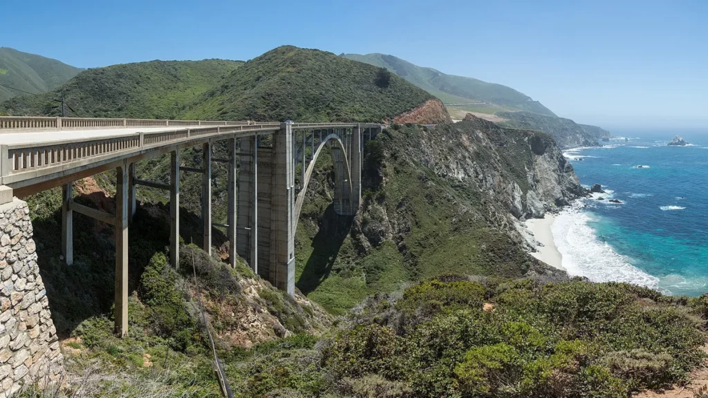
- Bixby Creek Bridge (mile ~15 from Carmel): the single most photographed bridge in California. Park at the north pullout and walk 200 yards south for the classic shot.
- Pfeiffer Beach: turn off at Sycamore Canyon Road (unmarked, easy to miss — it is 0.5 miles south of Big Sur Station). Purple sand, sea stacks, and a keyhole rock that frames sunset.
- McWay Falls: an 80-foot waterfall dropping onto a beach at Julia Pfeiffer Burns State Park. You view it from the overlook trail; the beach itself is closed to protect the ecosystem.
- Elephant Seal Vista Point: north of San Simeon, thousands of northern elephant seals haul out on the beach year-round. December through March is breeding season, when the big males battle — bring binoculars.
Overnight in San Simeon or Cambria. Cambria has the better food scene (Moonstone Beach boardwalk at sunset is a local ritual), while San Simeon puts you at the doorstep of Hearst Castle.
Day 3: San Simeon to Los Angeles (230 miles, ~5 hours driving)
If you did not tour Hearst Castle yesterday evening, consider the morning tour — the Grand Rooms tour takes 1 hour and shows the astonishing Neptune Pool and Roman Pool. Then drive south through Morro Bay (the 581-foot volcanic Morro Rock dominates the harbor; the sea otters in the back bay are reliably adorable), Pismo Beach (clam chowder capital), and Santa Barbara.
Santa Barbara deserves at least two hours: State Street for lunch, the waterfront for a walk, and the 1786 Mission Santa Barbara if you like history. From there it is 95 miles of freeway into Los Angeles. End your pacific coast highway road trip with sunset at Santa Monica Pier — the traditional terminus where Route 66 meets the sea.
The 5-Day Pacific Coast Highway Road Trip Itinerary (Recommended)
Five days lets your pacific coast highway road trip breathe. Keep the Day 1–3 plan above, but restructure with two extra overnights:
- Day 1: San Francisco to Monterey, with a proper afternoon at the aquarium and 17-Mile Drive at sunset.
- Day 2: Monterey to Big Sur village — but stay IN Big Sur (at Big Sur River Inn, Post Ranch Inn if the budget allows, or a redwood campsite). Hike the 4.7-mile Ewoldsen Trail or the short Pfeiffer Falls loop, and eat dinner at Nepenthe, the legendary cliffside restaurant.
- Day 3: Big Sur to Cambria via the southern half of the route (McWay Falls, Sand Dollar Beach, elephant seals). Tour Hearst Castle in the afternoon.
- Day 4: Cambria to Santa Barbara, with a detour inland to the Santa Ynez Valley wine country (Los Olivos tasting rooms, the Danish town of Solvang) or a slow morning in Morro Bay.
- Day 5: Santa Barbara to Los Angeles, with a Malibu beach stop — El Matador State Beach has the sea caves and rock formations of every California postcard.
This five-day pacific coast highway road trip itinerary is also the sweet spot for cost: four to five hotel nights, roughly 450 miles of driving, and enough unscheduled time to actually enjoy the roadside pullouts instead of sprinting between them.
The 10-Day Complete Pacific Coast Highway Road Trip: Leggett to San Diego
Want the entire highway, not just the famous middle? The full pacific coast highway road trip runs 655 miles from Leggett (where Highway 1 begins, deep in Mendocino County) to Dana Point, and many travelers extend to San Diego. Add these northern and southern legs to the 5-day core:
Days 1–2: Leggett to San Francisco (the Lost Coast and Mendocino)
Start at the Drive-Thru Tree Park in Leggett — yes, you can drive your car through a living redwood, and yes, it is worth the $15. Highway 1 north of San Francisco is wilder and emptier than the Big Sur stretch: the hamlet of Mendocino sits on headlands that look transplanted from Ireland, Point Arena Lighthouse offers tours to the top, and Bodega Bay (where Hitchcock filmed The Birds) has the best clam chowder bread bowls on the route. Overnight in Mendocino, then drive the Russian River wine country into San Francisco.
Days 3–7: San Francisco to Los Angeles (the 5-day core above)
Days 8–10: Los Angeles to San Diego (the southern coast)
South of Dana Point, Highway 1 threads through the surf towns of San Clemente, Encinitas, and Del Mar before reaching San Diego. Stop at the San Diego Zoo or Balboa Park, eat fish tacos in Ocean Beach, and finish at Sunset Cliffs Natural Park. Ten days, roughly 800 miles including the San Diego extension, and you have driven the entire California coast.
Best Stops on a Pacific Coast Highway Road Trip, Ranked
With 655 miles of coastline, you cannot stop everywhere. These are the stops that consistently justify the detour, in rough north-to-south order:
| Stop | Why go | Time needed |
|---|---|---|
| Mendocino Headlands | Dramatic bluffs, sea arches, storybook village | 2–3 hours |
| Point Reyes (detour) | Tule elk, the lighthouse, oyster farms | Half day |
| Monterey Bay Aquarium | World-class; the kelp forest tank is hypnotic | 2–3 hours |
| 17-Mile Drive | Lone Cypress, Pebble Beach coastline | 1–2 hours |
| Bixby Creek Bridge | The iconic PCH photograph | 20 minutes |
| Pfeiffer Beach | Purple sand, keyhole rock, sea stacks | 1–2 hours |
| McWay Falls | Waterfall onto a pristine cove | 30–45 minutes |
| Elephant Seal Vista Point | Thousands of seals, free, roadside | 30–45 minutes |
| Hearst Castle | America’s most extravagant mansion | 2–3 hours |
| Morro Bay | Volcanic rock, otters, harbor town charm | 1–2 hours |
| Santa Barbara | The American Riviera: mission, waterfront, wine | Half day |
| El Matador State Beach | Sea caves and rock formations at sunset | 1 hour |
Where to Stay: Best Towns for Overnights
Lodging strategy matters on a pacific coast highway road trip because the small coastal towns have limited inventory and summer prices can double. Book the Big Sur and Cambria nights first — they sell out earliest.
| Town | Vibe | Budget option | Splurge option |
|---|---|---|---|
| Monterey | Touristy but convenient, aquarium hub | Motel 6 / Travelodge | InterContinental Clement Monterey |
| Big Sur | Redwoods, isolation, $$$ | Pfeiffer Big Sur State Park campsites | Post Ranch Inn (cliffside, adults-oriented) |
| Cambria | Arts, Moonstone Beach, good food | Cambria Pines Lodge | El Colibri Hotel & Spa |
| Morro Bay | Working harbor, otters, casual | Estero Inn | Hotel 1110 waterfront rooms |
| Santa Barbara | Upscale Riviera feel | Motel 6 Santa Barbara Beach | Rosewood Miramar Beach |
| Mendocino | Victorian village on the headlands | Mendocino Headlands State Park camping | Brewery Gulch Inn |
If you are traveling in summer or on a holiday weekend, book Big Sur-area lodging 3–6 months ahead. State park campsites in the Big Sur region release on ReserveCalifornia and are typically gone within minutes for summer weekends — set a calendar reminder for the release date. Shoulder season (April–May, September–October) gives you the best combination of open roads, mild weather, and sane prices.
How Much Does a Pacific Coast Highway Road Trip Cost?
A realistic per-person daily budget for a mid-range pacific coast highway road trip (two travelers sharing costs) breaks down like this:
| Category | Budget | Mid-range | Splurge |
|---|---|---|---|
| Lodging (per night, shared) | $60–$90 (camping/hostels) | $150–$250 | $400+ |
| Food (per day) | $30–$50 (groceries + 1 meal out) | $60–$100 | $150+ |
| Gas (per day, ~150 mi) | $25–$40 (California gas is expensive; EVs save substantially) | ||
| Attractions/parking | $0–$15 | $20–$40 | $50+ |
| 5-day total per person | $575–$975 | $1,275–$2,150 | $3,000+ |
The biggest cost lever is lodging: camping even two of five nights can cut a mid-range budget nearly in half. The second lever is food — coastal-town restaurant prices are steep, so a cooler with groceries from a Trader Joe’s in San Francisco or San Luis Obispo pays for itself by day two.
Driving Tips for the Pacific Coast Highway
- Fill up before Big Sur. There are almost no gas stations between Cambria and Carmel, and the one in Big Sur village charges a painful premium. Top off in Cambria (southbound) or Carmel (northbound).
- Drive it in daylight. Big Sur has no streetlights, sheer drops, and frequent fog. Plan to be through the winding sections by sunset.
- Use the turnouts. California law requires you to pull over if five or more cars stack up behind you. Locals will tailgate you; let them pass at the next turnout and enjoy the drive.
- Expect fog in summer. The marine layer rolls in most summer mornings along Big Sur and often burns off by noon. Early starts still work — just drive carefully until it lifts.
- Download offline maps. Cell service disappears for long stretches through Big Sur. Download the route in Google Maps before you leave Monterey.
- EV charging: chargers are plentiful in Monterey, San Luis Obispo, and Santa Barbara but scarce through Big Sur itself. Charge to full before entering the Big Sur stretch.
Pacific Coast Highway Road Trip Packing Essentials
Beyond the obvious, a pacific coast highway road trip has a few specific packing needs: layers (coastal microclimates swing 30 degrees in a day), a real paper map or downloaded offline maps, binoculars for the elephant seals and whales, a cooler, a portable phone charger, and motion-sickness remedies if anyone in the car is sensitive — the Big Sur switchbacks are no joke. For the full checklist, see our road trip packing list.
Best Time of Year for a Pacific Coast Highway Road Trip
| Season | Pros | Cons |
|---|---|---|
| Spring (Mar–May) | Wildflowers, green hills, waterfalls at peak flow, fewer crowds | Some rain, possible late-season closures |
| Summer (Jun–Aug) | Warmest weather, longest days, all attractions open | Crowds, highest prices, morning fog, advance booking essential |
| Fall (Sep–Nov) | Warmest ocean temps, clearest skies, harvest season, fewer crowds | Fire-season smoke possible in bad years |
| Winter (Dec–Feb) | Whale migration, greenest hills, lowest prices, empty roads | Rain, highest closure risk, short days |
Locals will tell you September and October are the secret best months: the summer fog is gone, the ocean is at its warmest, the crowds have thinned, and hotel rates drop. If your schedule is flexible, aim for fall.
Extending Your Trip: Side Trips Worth the Detour
A pacific coast highway road trip pairs beautifully with these detours, each adding a day or two:
- Yosemite National Park (from the Bay Area): 4 hours inland from San Francisco; combine with the start or end of your trip.
- Channel Islands National Park (from Ventura/Oxnard): day-trip boat to otherworldly island hiking and sea caves.
- Santa Ynez wine country (from Buellton/Solvang): 100+ wineries, an easy inland loop off the route.
- Joshua Tree National Park (from Los Angeles): 2.5 hours east — desert contrast to the coastal drive.
- Point Lobos State Natural Reserve (just south of Carmel): locals call it the crown jewel of the state park system; sea lions, cypress groves, and turquoise coves in a 3-hour visit.
Frequently Asked Questions About a Pacific Coast Highway Road Trip
How long does it take to drive the entire Pacific Coast Highway?
Pure driving time for all 655 miles is about 12–14 hours, but that is meaningless — nobody should do it that way. Plan a minimum of 3 days for the San Francisco to Los Angeles core, 5 days for a comfortable pace, and 10 days for the full Leggett-to-San Diego route with real stops.
Is the Pacific Coast Highway dangerous?
It is a winding two-lane mountain road with sheer drops, so it demands attention, but it is not inherently dangerous if you drive it in daylight, stay in your lane, use turnouts, and never drive it impaired or exhausted. The accident rate is unremarkable for a rural California highway. Fog and wet pavement are the real hazards — slow down for both.
Can you drive the Pacific Coast Highway in an RV or with a trailer?
You can, but Big Sur is stressful in anything over 25 feet: narrow lanes, tight switchbacks, and limited parking. Vehicles over 45 feet are effectively impractical through Big Sur. If you are RVing, consider driving the route in a towed car or rental and basing the RV in Monterey or Morro Bay.
What is the best month to drive the Pacific Coast Highway?
September and October offer the best combination of clear skies, warm weather, small crowds, and lower prices. May is excellent for wildflowers and waterfalls. Avoid holiday weekends in summer unless you have booked lodging months ahead.
Is Highway 1 currently open through Big Sur?
Conditions change with every storm season. Check Caltrans QuickMap and the Big Sur Chamber of Commerce road conditions page before and during your trip. When closures occur, the standard workaround is driving the open portion out-and-back from one end or detouring inland on Highway 101.
How much gas money should I budget?
For the 5-day San Francisco to Los Angeles route (~500 miles including detours) in a car getting 30 mpg, budget $75–$100 at California gas prices. Add 30–50% for an SUV. EV drivers will spend roughly half that on charging.
Do I need reservations for anything on the Pacific Coast Highway?
Hearst Castle tours should be booked ahead in summer. Big Sur and Julia Pfeiffer Burns parking lots fill by 10 a.m. — arrive early rather than reserving. Restaurants like Nepenthe do not take reservations for most seating; go at off-peak hours. Hotels in Big Sur and Cambria should be booked months ahead for summer weekends.
Can I do a Pacific Coast Highway road trip in winter?
Yes, and winter has real advantages: migrating gray whales (December–April), the greenest hills of the year, empty roads, and the lowest hotel rates. The trade-off is rain and the highest risk of landslides and closures. Build a flexible day into your itinerary and check road conditions daily.
What should I pack specifically for this drive?
Layers for 30-degree temperature swings, binoculars for seals and whales, a cooler with groceries, offline maps downloaded, a portable charger, sunscreen (the coastal sun is deceptive), and motion-sickness remedies for the Big Sur switchbacks. See our full road trip packing list for the complete checklist.
Is it better to start in San Francisco or Los Angeles?
San Francisco (north to south) is better for the driving experience — the ocean stays on your side and pullouts are easier. Los Angeles (south to north) can be better logistically if you are flying into LAX or combining the trip with Southern California theme parks. Either direction delivers the views.
Ready for more inspiration? Browse our 25 best road trips in the USA for your next drive, or check 20 best weekend road trips if you are short on time. And if the open road has you hooked, our Route 66 guide covers America’s other legendary highway.